Stephenson Preserve

Trail
4.00 Miles
400 Feet
Free
3stars (3.35)16
2stars (2.34)
3point5stars (3.78)
N/A
No
No
No
Austin
Travis

Getting there: From MoPac Expressway in west Austin, turn onto William Cannon and head east. Turn left onto Brodie Lane and head south. Turn left at the first street, which is Paisano Trail. This narrow road will turn a couple of times to the right and left until it parallels LongView Park. Look for parking on the left. The Stephenson Preserve trail begins in LongView.

The Hike: The hike begins at the waypoint "Trailhead", which is actually in the adjoining LongView Park. The trail starts near swings, a basketball court, a pavilion and picnic tables, the usual park fare. The trail at the start here is paved and not particularly interesting. Where possible, head to the north onto the packed dirt paths to get to the preserve.

The trail in Longview Park itself is paved and easy as can be.
The Stephenson Preserve is part of the City Of Austin's Central and Eastern Preserves group, and as such the land is supposed to serve as a sanctuary for native plants and animals. However, Stephenson is either new to the Austin system or budget problems have curtailed any visible efforts to keep human impact on the land low.

Contrary to the official park map, the trails at Stephenson are not the simple out and back path that it shows. Instead, a twisted, criss-crossed web of trails come and go from all directions. The reason for this spaghetti factory is prior use by motorcyclists who cut a swath of denuded dirt where once grasses, bushes and trees grew. Neither motorcycles nor bikes are now allowed on the preserve and I'm sure they would like you to report any such activity. The city has plans to heal the damage and restore the area to a more natural state. In the years ahead this preserve should get better with age.
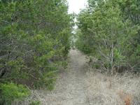
The trail in the preserve itself is either dirt or rock. And the trees close in on occasion.
Although overuse has caused a portion of the preserve to resemble a damaged lunar landscape, the majority of the preserve maintains some sense of solitude. On my trip I encountered no motorcycles or bikes, just a total of four people strolling along the trails.

The elevation changes are not too drastic and the trail is well worn and easy to follow. The hardest part of the hike was determining which way to go. As easy as it is to get turned around by the tangled trails, I was happy to have my GPS with me so as make sense of where I'd already hiked.

The preserve used to be a working ranch, as evidenced by the remains of these pens.
The preserve is a mixture of Juniper and Oak clumps and pocket prairies with open sky. Once this property was ranch land and there exists evidence of that use today in the form of rock walls and animal pens. The pens are located near the center of the preserve and the rock walls can be found in several places all around the property.

Hikers want lots of trails, but not necessarily overlapping each other. So hopefully as the city turns Stephenson into a proper preserve the trail system will be shrunk and the lunar landscape nurtured back a more natural state. Even so, Stephenson Preserve is large enough to allow the visitor to put the traffic of William Cannon and the damage to part of the preserve behind them.

Photos
Quirky Yard Art - Jester
Quirky Yard Art - Jester (Photo by plectrudis)
Quirky Yard Art - Smiling Heart
Quirky Yard Art - Smiling Heart (Photo by plectrudis)
A Green Grove of Mesquite
The trail--or one othem, anyway--winds through a grove of green mesquite, glowing in the evening sun. This one drops you off at LongView Park. (Photo by plectrudis)
Off the Paved Path
Following the advice from the original poster, I took the paved path back until I found a well-traveled looking dirt trail off to the left. This is that trail--paved path is at top of pic. (Photo by plectrudis)
Trail through a Cedar Brake
If you head northwest-ish, you enter a dense cedar grove with some nice little hills for variety. (Photo by plectrudis)
Keep Out
Wander around Stephenson long enough and you're bound to encounter one of the stone fences. (Photo by Austin Explorer)
Highway
Mountain bikers or motorcyclists have cut a confusing, highway like, matrix of trails through the preserve. (Photo by Austin Explorer)
Pocket Prairie
Clumps of trees open up into small prairies all around the preserve. (Photo by Austin Explorer)
Log Entries
Quirky Park, Tons of Shade; Trail Markers Please!
By plectrudis on 4/24/2017
Rating: 3stars Difficulty: 1point5stars Solitude: 3stars
Distance: 2.00 Miles Duration: N/A

There were parts of this trail that I really liked, and parts that were really annoying, so I guess that adds up to a 3 out of 5?

The best part: tons of shade--one of the shadiest trails in Austin--I love that!  There's a mixed deciduous woodland and a big cedar brake, and I was in shade more than 85% of the time, I think.

Also, the locals clearly have a quirky, artsy aesthetic, as the trail is decorated with metal yard art at various spots.  Not lots of it--just the occasional tucked-away piece to surprise you as you walk along.  This is fun.

The less good: botanically, it was a bit of a yawn for me--very little was blooming, and what there was is super-common--mostly horseherb and weedy non-native carrot relatives.  I did see a good bit of pearl milkvine in bloom, but overall, it was a bit ho-hum for a plant peeper.

And the worst part, as almost everyone else has mentioned, is the lack of any properly marked trails.  I was worried about getting lost, so although I took a number of random side trails, I ended the hike at 2 miles out of fear of losing my way.  I'm usually looking for a 3-5-mile hike after work, so this is not really satisfactory.

However, the shade will definitely bring me back, especially in the dog days of summer.

By ValEpiscopo on 4/19/2013
Rating: 3stars Difficulty: 2stars Solitude: 3stars
Distance: 3.00 Miles Duration: 1 hour, 30 minutes
Hiked in from Longview Park, around Stephenson's Preserve perimeter.
It was okay
By texaskdog on 6/27/2010
Rating: 3stars Difficulty: 2stars Solitude: 4stars
Distance: 2.00 Miles Duration: 1 hour, 10 minutes

Didn't see even one person, but could hear cars almost the whole time, so not sure how much "solitude" that is.  Got lost and wound up on Brodie. Nothing is labeled at all, even walking around the outside got lost.  No water or creeks.  The sculptures are pretty cool.  Saw 3 deer run from our right to our left about 20 feet in front of us.  Some cool things but not a very good park yet.

By Ollie on 3/10/2010
Rating: 3stars Difficulty: 2stars Solitude: 3stars
Distance: 0.80 Mile Duration: N/A
Wet Stephenson Preserve
By Ollie on 1/31/2010
Rating: 4stars Difficulty: 2stars Solitude: 5stars
Distance: 1.50 Miles Duration: N/A

The ground was soaked from a rainstorm a couple of days ago but it was still an enjoyable hike.  Saw some statues made out of the old barbwire from the old Ranch and I almost got lost a couple of times.  I would highly suggest bringing a GPS. 

Longview via wm cannon
By kathyhearn on 10/30/2009
Rating: 4stars Difficulty: 2stars Solitude: 5stars
Distance: 2.00 Miles Duration: N/A
I KNOW THAT PARK LIKE THE BACK OF MY HAND
By jgrussatx on 3/12/2009
Rating: 5stars Difficulty: 5stars Solitude: 5stars
Distance: 100.00 Miles Duration: 20 hours

I remember going to this place as as a teen over ten years ago.  My friend lived in the neighborhood and we all hung out there every day.  Infact my friend is the one with the dirt bike responsible for your trails.  What most people dont know or forget is the cemetery located in the park.  And the fact that its haunted Ive seen two ghost children and a tiny little creature walking on its hind legs SERIOSULY BEWARE

By wallis on 1/6/2009
Rating: 3stars Difficulty: 3stars Solitude: 4stars
Distance: 3.00 Miles Duration: 2 hours
Where the heck am I?
By perk1963 on 3/13/2007
Rating: 3stars Difficulty: 2stars Solitude: 4stars
Distance: 3.00 Miles Duration: 45 minutes

Thank goodness I brought my dog. He seemed to know where to go, for the most part. I made a small loop first that only took about 10 minutes. Headed up the paved path and cut off to the left at the first sign of a path. It meandered around a bit and brought me back out the other side of the park. We then went up the paved path again and cut off to the left at the end of the path. Lost the path for a bit but were behind houses--found another path that was open field and found some residents walking along that path--doubled back into the wooded area and followed a trail downhill (and through a pretty muddy area) and back into the park again. Not sure what ground I actually covered or whether I ever made it onto the actual preserve. Had fun with my dog and made for a brief adventure.

Only showing last 10 log entries. View All Log Entries

Recommended Item
Recommended Item 60 Hikes Within 60 Miles: San Antonio and Austin: Including the Hill Country
Charlie Llewellin, Johnny Molloy
List Price: $18.95 Your price: $12.59 Buy Now
It's Time to Take a Hike in San Antonio!

The San Antonio and Austin areas are steeped in history -- San Antonio's Alamo stands as a symbol of Texas' fierce independence, while Austin is recognized as the cradle of Texas statehood. This area is also known for some of the most impressive hiking in the Lone Star State. 60 Hikes Within 60 Miles: San Antonio and Austin, by veteran authors Charlie Llewellin and Johnny Molloy, guides readers to the best trails found in the Texas Hill Country, all within easy reach of these two cities. The guide takes you to secluded, low traffic areas as well as those that are more popular and heavily used. The former LBJ Ranch, the Guadalupe River, the Highland Lakes Chain, and the Lost Pines area are just some of the spectacular places covered.

With this new edition in the best-selling 60 Hikes Within 60 Miles series, all these visually stunning and ruggedly charming routes are at the traveler's fingertips. This handy guide helps San Antonio and Austin natives get back into nature, with many options right in town. Extensive at-a-glance information makes it easy to choose the perfect hike based on length, difficulty, scenery, or on a specific factor such as hikes good for families, runners, or birding. Each trail profile includes maps, directions, driving times, nearby attractions, and other pertinent details.