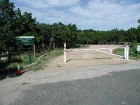
Despite conflicting information on city maps and a closed parking area, this trailhead is open for visitors. However, the sign now says 'Stillhouse Hollow' and not 'Spicewood Springs'!
From central Austin, head north on MoPac and take the
Anderson Lane/Spicewood Springs exit. Turn left and head west on Spicewood Springs to Mesa Drive. Turn left on Mesa and head south to Burney Drive then turn right. Head west on Burney Drive and park along the street near the intersection with Rustling Road. The preserve entrance is on the north side of Burney, slightly to the east of Rustling Road.
The Hike: Is someone trying to keep us away from this hike? It seems that way, considering all of the difficulty we had in locating it. First, our street map shows a park by the name of Stillhouse Hollow Park near this location where a row of houses resides. The official City of Austin Parks and Recreation Department parks map at the time showed a Stillhouse Hollow park here where there was none. Since our initial visit to this preserve the Spicewood Springs sign has been replaced by a Stillhouse Hollow sign and hopefully we can finally put to rest that name for this hike!
-small.jpg)
The start of the trail has some open spaces, but that soon ends.
On the last street that we investigated we spotted the entrance to the preserve, but the gate
was closed. According to the sign at the entrance the preserve was open, but the gate leading to
a small parking are was locked. Unwilling to be turned away we parked the car along Burney
Drive and ventured forth to see what was someone was apparently trying to hide from us.
The trail begins at the waypoint "Trailhead", situated next to the locked gate which prevents
visitors from parking in the half dozen spaces constructed for the park/preserve. The trail
follows the paved path to left. The entire length of the trail is paved, which makes for an
easy stroll for hikers of all abilities.
-small.jpg)
The preserve trail is mostly covered by a thick canopy of Cedar.
The preserve features thick stands of Mountain Juniper that provide ample shade from the Sun.
Parts of the hike are almost dark in comparison to the glare one might encounter in the one open
area of the trail near the parking spaces. In general the trail gently slopes downward on the
way out, as it approaches the edge of a steep creek valley.
-small.jpg)
The trail surface is paved throughout, making the hike easy for all.
All through our hike we expected the trail to end at any moment. We were pleasantly surprised
when the path was extended again and again through turns in the Cedars. Eventually the trail did
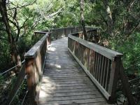
end. But a surprise awaited us in the form of an impressive wooden deck that overlooks the steep
drop into the canyon of a creek that eventually feeds into Bull Creek. On the day of our visit
there was a pleasant cool breeze shooting through the valley and the deck provided a wonderful
place to stop for a rest.

At the end of the trail is this surprising observation deck that sits on the edge of a steep drop into the canyon.
The trail doubles back on itself back uphill towards the trailhead. In all, this small preserve
provided over half a mile of surprisingly secluded hiking within a stone's throw of the many homes
that surround it. We hiked the trail in about xx minutes, but wished we had spent some more time
sitting at the deck overlooking the canyon.
Austin features another nearby component to the Balcones Canyonland System in Barrow Preserve.
That land sits but a few blocks to the west of this trail. Thus far we have not found any
trails in Barrow Preserve nor any connecting trail between the Stillhouse Hollow and Barrow
preserves.