-small.jpg)
The start of the journey near the trailhead.
Head west on Barton Springs Road and turn left at the
first available turn after entering Zilker Park. Drive south as far as possible in the
parking area next to Barton Springs Pool.
The Hike: This hike starts at one of the crown jewels of Austin,
Barton Springs Pool. The spring water feeding this pool provides a constant temperature of
68 degrees year round. Prior to air conditioning these cool waters were a town favorite
for beating the oppressive summer heat.
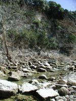
Barton Creek meanders past several sheer rock walls.
The trailhead starts just west of the Barton Springs Pool parking area. On our visit this
was blocked by a large number of construction vehicles being used to place new drainage
pipes under the trail. We saw many signs of their work along the first half of the
hike. Until the construction is complete there is a well marked path around the construction
area that quickly turns back toward the creek and then begins its journey upstream and
away from the center of town.
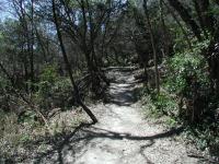
The greenbelt trail is fairly easy to navigate and never gets hilly like some of the hikes
farther upstream. However, the trail can get a bit rocky at times and careful footing is
required to avoid twisted ankles. Despite the occasional rough spots this section of
the Barton Creek Greenbelt is popular with runners in addition to hikers and mountain bikers.
Although the terrain gets slightly rough here and there the trail is popular with many runners.
If the rocky spots don't get you maybe the drainage pipes will. An unfortunate companion
for the first quarter of the trip was the new pipe the construction crews were preparing
for burial. Once in place they will largely be invisible, save for the occasional manhole
cover, but in the meantime it serves as a stark reminder of just how close to the center of the city the trail is.
The first waypoint marked "Waterfall" is an interesting jumble of rock just off of the main trail.
Head toward the sound of running water in wetter periods. In drier periods it's possible
to see through some of the treecover and the shape of the rock is interesting regardless
of whether there is running water or not.
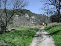
On this portion of the Barton Creek Greenbelt one is never too far from someone.
As the trail nears the bend in what is known as Gus Fruh Park there are a multitude of
side trails and forks in the path. In general, it is fairly easy to discern the main path
and the lesser travelled paths. On our trip, we diverged from the main path unintentionally
for a moment where Barton Creek splits into two temporarily. As you can see from the
topo map we eventually joined back up with the main path at the waypoint "Main Trail".
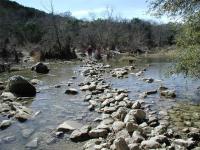
The major creek crossing on the trail is not too difficult. Expect to get wet with higher creek levels.
The "Creek Cross" waypoint marks the spot of the main creek crossing.
In wetter periods this crossing may require getting a little wet. However, there are
typically so many rocks piled up along this stretch of the creek bed that it's usually
possible to tip toe one's way across without too much difficulty.
The rest of the trail is an easy, well shaded straight shot to 360 Trailhead. At the
last waypoint marked "Y-Left" take a look to your right across the creek. On nice days
the sheer rock wall on the opposite bank is one of the most popular rock climbing spots
in Austin.
The 360 Trailhead is the turnaround point for this hike. Hikers looking for a shorter
hike can arrange to use a two car shuttle system with friends leaving one car here for the drive back to Barton Springs Pool. For those making the round trip take solice in the fact that hike back is all downhill!
This hike was not nearly as pleasant during our visit as it will be once the construction
is completed. If you elect to start from the Loop 360 Trailhead and turn back near the
"Captain's Treasure" waypoint you can enjoy the majority of this hike without having to
encounter construction equipment. Hopefully the entire trail will be returned to
the runners, bikers, hikers and animals in the near future.