Getting there: From Highway 183 in northwest Austin turn south onto
Spicewood Springs Road. Continue south for several blocks and look for Canyon Vista Middle
School on the right. Park in front of the school and walk to the opposite side of the
main building. A large green transformer sits next to the trailhead.
The Hike: I began the hike at the waypoint "Trailhead", which lies at
the back of Canyon Vista Middle School. The trail at the start of hike is fairly well
maintained, though it's a bit rocky as it descends to the creek bank. From here the trail technically forms a T junction where one can go left or right. However, the larger trail goes to the left.
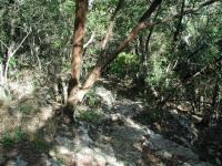
The initial few hundred feet of the trail descends down a rocky slope to the creek bed.
For a short distance the trail is pleasant and relatively flat. The trouble soon begins
as brush and vines close in. At a couple of points I almost had to push my way though
vegetation to keep going. Some of the debris may have been deposited by a flood in the
not too distant past, though none had occurred recently.
The Upper Bull Creek Greenbelt lies a short distance from
both St. Edwards and Talleyran Parks. Yet this one seems to have been forgotten and
relegated to second class status, despite its promise. The nature of floods in this
creek valley may have played some role in getting to its current state. Strong city
or community support appears to be lacking and the park suffers as a result.
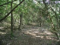
Near the trailhead the paths are fairly mild and pleasant. The troubles begin father from the start.
The dense vegetation does have its advantages. On two occasions on this hike I spied
white-tailed deer as they darted away from me. One of the deer huffed a warning as they
sped off.
A small pond lies on the trail at the waypoint of the same name. The water tends to be
a bit brackish here, but a father and son were fishing on one of the two small piers that
stand on the edge of the water.
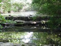
Several small waterfalls dot the path of the creek through the park.
Beyond the pond, the trail continues for a short distance before gradually fading from
view. The trail does not end so much as it tends to become narrower and less pronounced.
By the time I had progressed to the waypoint "Turnaround" the trail resembled an animal
trail more than a hiking trail. This seemed a bit odd since the terrain here could
easily support a trail and the park continues for some distance to the south.
Most of the trail is flat and follows the creek. Side trails that ascend from the creeks get a little rocky.
Upon tiring of pushing through the Juniper branches, I doubled back and retraced my steps
back to the trailhead. Before scrambling up the rocky slope near the trailhead I ventured
to the right of the T section and found the trail was short and well covered with litter.
I don't recommend bothering with this portion of the trail except for doing a little
community service by picking up a bag of trash on your visit. We need more people pitching
in like this to help clean up this park. There is a large
dumpster at the back of the school, opposite the side with the pool. Please make use
of it and help clean up the area.
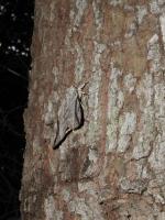
White tail deer were not the only wildlife noted. This moth was one of many on a single tree.
The state of this park is puzzling. It's surrounded by a nice neighborhood. It has
several nice features that should make it a showpiece for the area. But it seems to have
been largely forgotten except by kids and those who see fit to dispose of their litter
instead of packing it out themselves.
Although I only saw two other people on the hike I've given it a less than stellar
solitude rating. In part this is because many of the houses lie a short distance from
the trail. But the frequent signs of the surrounding developments, mainly in the form
of trash, serves as a constant reminder that you have not gotten very far away from
anything.
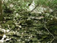
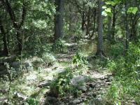
Following the less developed trails leads one to some nice spots like this feeder stream.
It is possible to find some quaint spots on this trail and I did that near one of the
waterfalls. Just downstream a large Sycamore tree had toppled over. As the roots were
yanked from the ground they grabbed a large amount of rock and soil with it. I thought
the tree was recently felled, since I could see green leaves on its branches in the
distance. Upon closer examination I noticed something odd about its trunk, or should I
say trunks, since this tree's trunk forked near the base. From the trunks vertical
chutes sprouted and rose towards the Sun, each bearing large, green Sycamore leaves.
The tree was still alive!
I thought that the tree was a good metaphor for this park. Lots of promise, seemingly
on its knees and left for dead. But the potential remains, if one does not give up.
Let's not give up on this park.