Getting there: From central Austin, take FM 2222 west to FM 620. Turn
right on 620 and head north to Boulder Drive in the Canyon Creek subdivision. Turn right
onto Boulder Drive and look for Trailhead Park on the left side of the road.
The Hike: Trailhead Park's trail resides at the back of the park's
playscape, pavilion, basketball court and volleyball court. There's no sign indicating
its presence, so one might very well miss it if only idly searching for a place to hike.
Near the waypoint "Trailhead" the path forks almost immediately. To the right, a short
spur leads to an alternate trailhead along a different street. Continue to the left for
the main trail.
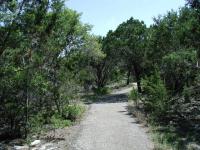
The first portion of the trail is paved, but some rougher stuff lay ahead.
The start of the trail consists of a paved walkway that resides near the edge of a ridge
over the creek below to the left. Here the path is flat and occasionally passes by the
back fences of some of the homes in the area.
The trail changes abruptly at the waypoint "Pavement Ends". A few benches mark the spot
where the trail surface transforms from smooth concrete to a rocky slope down to the creek.
This is where the fun begins.
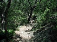
Immediately following the paved trail the path leads down a rocky slope to the creek bed.
Once the trail descends to the creek it turns south and follows the creek downstream,
sometimes just a few feet away. While rocky, the path is relatively flat here and wide
enough to drive a jeep through, if one was so inclined. Why so straight and wide? You
might notice manhole covers here and there along the route. The city appears to be using
the creek bed as a sewer line conduit.
Although not adjacent to backyard fences, one is constantly reminded of the surrounding
environment from the yelling kids, pool splashing, barking dogs and power tools. It's
not like walking through a sonic assault in the center of a city, but the typical
tranquility that can be found here is punctuated now and then by abrupt reminders. It's
time to keep going.
-small.jpg)
Sometimes rocky, sometimes not, the trail along the creek is typically flat. The wide trail also provides relatively little shade from a high Sun.
The waypoint "Deer Feeder" marks a clearing on the opposite side of the creek. In previous
hikes, we had seen a deer feeder in place here and just happened upon a few deer browsing
the area for some feed corn. Although no deer were present on this particular trip, there
was a surprise in store. Startled by my presence a huge bird took to flight, its massive
wings thumping in the air. It was like watching a 747 take off instead of a jet fighter.
It gained altitude and skimmed above the ridge on the opposite side of the creek and over
a rooftop. As it did so, a family at play in their pool, out of sight, but audible,
gasped and called attention to the bird, which appeared to be a Blue Heron.
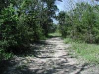
Much of the trail along the creek bed is surprisingly straight.
The trail crosses the creek several times, but none of the crossings are difficult and
other hikers have placed bits of wood and rocks to make the traversals easier. I sat at one
crossing for some time to watch the unlikely dance of mating Damselflies. With the end
of one's abdomen attached to the thorax of the other, it seemed an amazing feat that they
were able to move around at all. Imagine carrying around someone on your back who's
wearing stilts, and you get the idea.
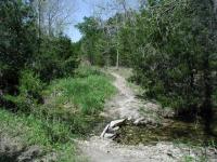
Getting to the end of Trailhead requires a few creek crossings. However, none of them proved to be difficult.
The farther one goes back on the trail the more tranquil it gets, at least for now. Not
far from the waypoint "Turnaround" a wonderful spot passes right next to the creek and
includes a couple of small rapids that fill the air with soothing sounds of running
water.
-small.jpg)
About halfway down the hill from the construction site looking southeast. The end of the trail lies below. On the ridge opposite the creek new homes are sprouting up to join those already built.
The waypoint "Turnaround" marks the spot at which the trail runs into the northern
boundary of one of the Balcones Canyonland Preserve parcels. The preserve is off-limits
and is intended for the preservation of habitat for endangered species.
A wide trail to the right led to the top of the hill and provided a hint to the changes
in store for this relatively tranquil area. A cul-de-sac was being constructed with lots
arranged around its perimeter. To the east, on the ridge opposite the creek a number of
houses had already sprung up, with more being built up to the edge of the preserve.
Relatively inaccessible, this area will soon be in someone's backyard as well, so get
there while you can.