-small.jpg)
The wide trail and open spaces all around provide for lots of Sun.
From I-35 near central Austin, take the Riverside Drive exit and head east. Turn left on Pleasant Valley Road and head north. Turn right into the Krieg Field Softball Complex, immediately after the Austin Fire Department training tower. Keep to the right and continue all the way to the back of the parking area.
The Hike: The City of Austin has big plans for Guerrero Park. This 363 acre park is comparable to Zilker in size and the city of Austin hopes to match it in features, providing top notch recreational opportunities for the east side of the city.
-small.jpg)
This small creek parallels the trail for some distance before discharging into the river.
Besides the Krieg and Montopolis playing fields on either side of the park, the land is still largely untouched. One of the newest additions is the hike and bike path that was added as an extension of the
Town Lake trail system. We began our hike at the waypoint "Trailhead".
The trail parallels the parking area and a small creek to the right before making a turn onto a gully crossing constructed of concrete. The amount of trash that collects here is very disappointing, but don't let it disturb your overall enjoyment of the day. Compared to the washed down trash found here, the rest of the park was largely litter free. Bring along a trash bag and help collect some of the rubbish on your way out.

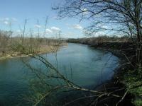
There is only spot along the trail that provides a good look at the river.
The path surface is crushed gravel and the trail is mostly flat and largely straight. Sure the path curves a bit to the right as you head east, but for large portions of the hike the path before you appears straight as an arrow. There are plenty of trees, but they do not tower over the trail, so there is plenty of direct sunlight for most of the hike.
-small.jpg)
At the creek crossing near the trailhead there's some shade, but that won't last long.
The land here is undeveloped, but hardly untouched. One of the most common trees seen near the trail was the Chinaberry, an introduced species that crowds out native varieties. In some parks the city attempts to curtail these and other invasive species to return the balance towards native plants. We're uncertain if that is in this park's plan.
At the waypoint "Overlook" the trees give way to a slight opening that provides some views of the Colorado River. Be careful not to venture too close to the edge of the bluff overlooking the river since it is largely made up of dirt here and could give way.
The trail ends at the Montopolis Sports Complex on the eastern side of the park. We hiked the trail on an absolutely beautiful, sunny Sunday afternoon. So we found it a bit odd that this complex of ball fields was completely empty and locked up. Perhaps these fields are only used for league games.
The trail ends at the sports complex, so we retraced our steps back to the trailhead. In an hour and a half of hiking we only saw a handful of people even with the spectacular weather. Though not a challenging experience the trail's relative solitude makes it an
attractive alternative to the often busy Town Lake trail.